Village history
Jump to:
- Kings Beck Backstory
Early History of Tuttington
The land around Tuttington was likely very different in pre-history. Before 6500 BCE, Britain was still linked to mainland Europe by low-lying marshland covering much of what is now the southern North Sea. Archaeologists call this area Doggerland. Around 6200 BCE Britain became cut-off from the rest of Europe (sounds familiar) as the North Sea level rose. This could have been as a result of melt-water at the end of the last ice age. There is also evidence of a mega-tsunami originating from large undersea landslides off the coast of Norway sweeping south and inundating Doggerland. It is strange to think that a tsunami could have had a direct impact on the land that was to become Tuttington.
The first evidence of human activity around the village was from the Neolithic era (from about 4200 BCE) with findings of flint tools and other artifacts and bones associated with burial structures called barrows. One such barrow is believed to be near the junction of Stow Heath Road leading to Hyltons Crossways, and Tuttington Road – which becomes Beck Lane (see panel). Another barrow – or group of barrows – is in the woodland near the junction of Aylsham Road and Wood Lane (see panel). This structure may have been built a little later that the Stow Heath barrow, in the Bronze Age (from about 3000 BCE).
Circular crop marks are also visible in a field just south of Tuttington, east of Norwich Road. These structures have a central feature. Perhaps they were ancient buildings (see panel). A possible track from the south passes to the east of the largest circular crop mark and then on to the Wood Lane barrow.
Romans and Saxons
There is much evidence of Roman occupation in the district especially around the neighbouring village of Brampton where pottery was made for several hundred years. A Roman road originating from mid-Norfolk and beyond is thought to have passed near Brampton, crossing the Bure at Oxnead. Although the road is believed to have extended towards the coast east through Dilham, some 19th Century scholars suggest the road headed in the Tuttington direction through Stow Heath. It is interesting to note that Stow Heath Road has a long straight section, a characteristic of Roman Roads.
Archaeologists working in the area have made finds considered to be from the Saxon era which overlapped the period of Roman occupation and extended up to the Norman Conquest in 1066. After the Romans left, Tuttington became part of the kingdom of the East Angles. It is likely that an early church was established in Tuttington during this period.
1066 and all that…
After the Norman invasion of 1066 and subsequent occupation of England, there are more written records about our local area. Much of this history is associated with development of the church and ownership of land. Among the first records of this medieval period is Domesday Book. Summarising the information on the Open Domesday website there are two entries for Tuttington, called at the time Tatituna or Tutincghetuna (see panel). In the first entry, it names connected nobles as Earl Harold, Earl Ralph the constable, Earl Gyrth and Archbishop Stigand, Turold and William of Warenne. In the second, the settlement is listed under the aegis of The Abbey of St Benet at Holme. There is also mention of a mill.
For an interesting short history of Tuttington church follow the link to this pamphlet.
There is a further point of historical interest relating to the church. In the village today, there are two houses with apparent eclesiastical connections: The Old Vicarage and The Old Rectory, located in different parts of the village. The records show that a Rectory was established in Tuttington in 1234, but that a Vicarage was later endowed in 1275.
Rebellion
Although Tuttington is rather a quiet place today, there have been times in the past when the sniff of rebellion was about. One such rebellion caused the Battle of North Walsham which occurred on 25 or 26 June 1381. The battle took place 3 miles east of Tuttington and could well have involved people from the village.
The battle was the last expression of resistance during the Peasant’s Revolt of 1381 which had spread throughout East Anglia that year. The main protagonists were Geoffrey Listster (a resident of Felmingham) for the rebels and the so-called fighting Bishop Henry Le Despenser. Listster reputedly mustered his small force on Thorpe Market green whilst Despenser gathered his army at Felmingham. Listster lost the battle due to the overwhelming forces led by Despenser. The rebel leader was subsequently executed in Norwich; members of the surviving rebel band were likely put to the sword.
A later rebellion – in 1549 – which had echoes of the Peasant’s Revolt was led by Robert Kett who shared the desperation of the poor when common land became subject to enclosure. Although the action took place mainly within, and south of, Norwich, the effects were probably felt throughout Norfolk. Needless to say, this rebellion was also put down but only after Kett and his followers had captured Norwich, England’s second most important city at the time. Kett suffered a similar fate to the rebel Listster.
More rebellion on a national scale followed in 1642 as the English Civil War began. Norfolk was a supporter of the Parliamentary cause during the Civil War although there were hotspots of Royalist supporters. Most of the fighting took place in the west of the county, but there was considerable unrest in and around Norwich which must have been felt here in the village.
Industry
Industrialisation arguably started with the building of mills, powered by water or wind. Tuttington had a mill recorded in Domesday Book. The waterways about these parts were a good source of energy and local mill buildings today are still to be found on waterways at Felmingham, Buxton, Oxnead, Burgh-next-Aylsham and Aylsham itself. Mills have been used to grind cereal for flour, bone for fertiliser and to spin yarn for the wool trade. Wool played a major role in generating wealth for Norfolk. The large number and size of churches in Norfolk is due in part to the success of the wool trade. Norwich became the second most important city in England in Tudor times, because of the success of wool merchants.
As energy became less associated with water and wind, and more with coal and steam, the importance of our region in wool waned. But, this part of Norfolk has rich soil, and a high level of agricultural production continued to underpin the local economy.
Canals and Railways Come and Go
Development of transport links helped Alysham and surrounding villages make the most of their agricultural productivity. Our local canal, the Bure navigation, was developed along the river. Changes in level were bypassed by constructing locks and loop channels. The remains of old locks can be seen in Burgh and Oxnead. The canal opened in 1779 and Norfolk wherrys plied their trade between the staithe in Aylsham and various destinations along the Norfolk waterways and the coast. The Bure navigation was never a busy canal and it finally fell into disuse after a catastophic flood in 1912 which damaged much of the infrastructure.
Aylsham was also served by two railway stations. Aylsham South (formerly the Great Eastern station) was built in 1880 on the line between Wroxham, where it joined the Norwich-Cromer line, and County School on the line between Dereham and Fakenham. The line finally closed in 1984. Aylsham South still has trains today – but on a smaller scale than before – as it is the base of the Bure Valley narrow gauge railway.
The other station was Aylsham North on the Midland and Great Northern Joint Railway – M&GN (known affectionately as the ‘muddle and get nowhere’). The line was built in 1883 and succumbed to dwindling passengers and freight as road transport took over. The line was abandoned in 1959, a few years before Dr Beeching wielded his axe on our national rail network. The Aylsham North station site is in the Dunkirk district of Aylsham and the straight section of road by the industrial estate to the A140 follows the old railway track-bed. Residents of Common Lane in Tuttington and elsewhere still use the old M&GN trackbed for recreation where it passes just north of the village.
More…
History of Norfolk Volume 6; Norfolk Heritage Explorer; Domesday Book of 1086; Open Domesday website
The Medieval mill at Tuttington and other interesting historical possibilities have been discussed at length by our own resident historian and sleuth Sid Kettle of Thieves’ Lane. You can download two of his fascinating historical essays about Tuttington here: The story of Beck Lane; Tuttington Through the Ages
There is a further summary of the history of Tuttington church, St Peter and St Paul, available as a pamphlet in the church or you can download a copy here: St Peter and St Paul Tuttington. A Short guide to the church.
If you would like to see some old maps of our area, go the the Norfolk County Council Historic Maps website or (strangely) The National Library of Scotland


Click the images above for a larger view. Top: crop marks just south of Tuttington: © Infoterra Ltd and Bluesky Google Earth. Bottom left: crop marks at Stow Heath just east of Tuttington: © Infoterra Ltd and Bluesky Google Earth. Bottom right: LIDAR image of the barrow (near centre of the image) at the Tuttington end of Wood Lane: © Environment Agency copyright and/or database right 2015
What’s in a Name?
The entry in Domesday Book indicates that the name Tuttington has existed in different forms, including Tatituna, Tutincghetuna, Totingtonne, Totington, Tutington and, of course, Tuttington.
It seems generally to be accepted that the village got its name from a possible enclosure of Tutta’s people, perhaps from the Saxon or an earlier period. There is an alternative explanation as suggested by some scholars, including the Modern Antiquarian, that the name might have originated from the presence of a mound, maybe the barrow near Wood Lane. The suggestion is that the term is from old northern European words, Tutta or Tuta, alluding to a nipple-shaped or teat-like prominence, perhaps describing the shape of the burial mound. Did Tutta take his name from these symbols of Life and Death?
The Earl’s Fair at Tuttington
In descriptions of the history of Tuttington church, there is mention of a chapel located just to the north of St Peter and St Paul in an area called Meton-he. The chapel built apparently before 1214 was dedicated to St Botolph and there is reference to a fair being held there on St Botolph’s Day (June 17th). There is further record of the St Botolph’s Day fair in Tuttington in 1285 at which time it was called the Earl’s fair in honour of the Earl of Norfolk, Roger Bygod. Perhaps the residents of Tuttington might consider reviving this old tradition to hold a fair on June 17th in those years when there is no Open Gardens Day?
Kings Beck Backstory

Origins of the beck
The stream flowing along the eastern edge of Tuttington is familiar to most local residents, and, especially the dog walkers who cross the humped back bridge on Beck Lane and hear the sound of water flowing over the shallow weir nearby. According to our local historian, Syd Kettle, a mill might once have stood near to where the bridge is now, using the drop in river level to capture energy for grinding corn. Our beck has probably been an important feature of the area for many hundreds of years for power, as a water source, and as a drain.
Most folk know this waterway as King’s Beck. But, others call it Blackwater Beck. What are the origins of the beck and its confusion of names, and is there a regal connection?
To understand any natural waterway, the first origin to identify is the source. Maps show that the beck flows largely from north to south – with several inflowing tributaries – finally emptying into the river Bure at a remote spot called Lady’s Bower between Oxnead and Buxton. On detailed maps many additional minor watercourses can be seen associated with the beck. This is because the natural course of the stream has been much altered over time with addition of many drainage channels.
Referring to the numbers shown on the main map…

1. The source

Tracing the route of the beck on a map as far upstream as possible locates its source near a pond northwest of Roughton. The pond (at the centre of this map) lies in a garden – originally a farmyard – between Felbrigg Road and Back Lane near to the junction with Chapel Road and Metton Road. The source itself might be a spring a little to the north of this site. Beyond, rises the Cromer Ridge which collects the water subsequently emerging at the source.
Downstream, closer to Roughton is a fishing pond most likely produced by damming the beck. A strange fact about Roughton is that it was visited by Albert Einstein in 1933 as he was fleeing Nazi Germany. He liked to sail but there is no mention whether he fished in Roughton.
2. Hagon Beck

Maps name the upper reaches of our stream Hagon Beck which has its own Wikipedia entry. Hagon Beck flows almost unnoticed through Roughton, under the A140 next to the garage and on in a south-easterly direction towards Gunton where power is still taken from the water.
3. Two water mills of Gunton
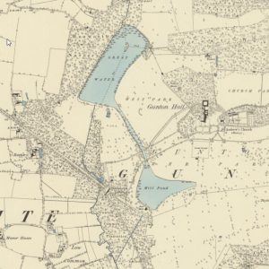
There was once an old corn water mill with a mill pond on Hagon Beck, mentioned in Domesday Book, within what is now Gunton Park. There is a loop in the beck which diverts some water towards the old mill pond and the other branch flows to the west.
The southwest corner of Gunton Park was decoratively landscaped in the middle of the 18th century producing the Great Water fed by Hagon Beck. This is connected to the lower lake, the (saw) mill pond, by a canal. Both lakes were produced by damming the water flow. The old corn mill associated with the lower lake was eventually replaced by a wood saw mill which is still in working order. The loop branch from the saw mill rejoins Hagon Beck just to the south of Gunton Park.
4. Blackbushe Beck

Further beyond the southern re-joining point of the Gunton loop, drains from the eastern part of Gunton Park merge in Pond’s Head Plantation and empty into the Beck close to Suffield Corner. A large lake was recently landscaped in Pond’s Head Plantation by construction of a dam on the fused drains close to the road near Suffied Corner.
Downstream of this confluence, it is no longer Hagon Beck but the stream becomes Blackbushe Beck. It flows almost due south through Colby. The straightness of Blackbushe Beck along this reach together with the adjacent water meadow drains shows how much the flow of water has been altered by human intervention.
5. Felmingham watermill

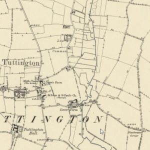
Felmingham watermill near the school at Colby Corner lies at the junction of two becks. Blackbushe Beck from the north meets Suffield Beck from the east at the mill pool which has changed over the years. The mill was originally used to grind corn but the millstones were later changed for grinding animal feed and fertilizer.
The mill straddles the beck emerging to the south of the mill pond. The mill race took its power from this stream called Blackwater Beck.
6. Blackwater Beck and Tuttington
The map above is dated 1886 and shows where Beck Lane crosses the beck next to Lower Farm. It clearly shows that it is Blackwater Beck flowing through Tuttington and not King’s Beck. Some modern maps show King’s Beck at this location but others still use the original name of Blackwater Beck.
Further along Beck lane, a junction is reached with a road to the left leading to Hylton’s Crossways. This junction is called Blackwater Corner and it was at one time a crossroads.
7a. The old river crossing

In earlier times, there was a road heading south from Blackwater Corner. It is now a farm track that passes along side the beck for a short distance and then crosses it. The crossing point was originally a ford. Beyond the crossing, the road comes to an abrupt halt while the beck swings south-east. Just before the beck turns to the south again, a tributary flows in from the north east. This is Skeyton Beck.
7b. Black Water Lane

The old tithe map from the mid 1800s shows that the truncated road crossing Blackwater Beck by ford was then called Black Water Lane. Although the road seems to end at a building, crossing rivers by bridge or ford created an expensive problem to overcome. The provision of a ford suggest that Black Water Lane might have extended further at an earlier time.
7c. Where is Beck Lane?

Faden’s map of Norfolk dated 1797 (above) shows Tuttington with its church and Norwich Road heading south. There seems to be no sign of Beck Lane. But, the ford across Blackwater Beck (on the right of the map) is clearly present and Black Water Lane extends west to join Norwich Road. This suggests that the ford along Black Water Lane was at one time the principal means of crossing the Beck at Tuttington and not the crossing at Beck Lane.
8a. Any sign of King's Beck?
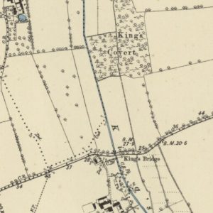
The naming of becks seems to follow a pattern. After the confluence of any two streams, the joined waterway adopts a new name. So a new name should be expected after Blackwater Beck is joined by Skeyton Beck just downstream of Black Water Lane ford. Surely, this must be King’s Beck?
Indeed the map of 1885 shows the stream as King’s Beck flowing beside King’s covert and under King’s Bridge. And then it flows a little further south before joining Stakebridge Beck and the Bure.
8b. Is it a beck - or a back?

So it seems that King’s Beck is a relatively short stretch of waterway beginning over a kilometer downstream of Tuttington and ending at the Bure after a further 1.5 km.
But Bryant’s map of Norfolk dated 1826 (above) seems to tell a different story. King’s Bridge shown on the 1885 map went by a different name on the earlier map. It was called Blackwater Bridge. So where is King’s Beck? A clue lies elsewhere in Bryant’s map. Just to the east of the beck is a geographical feature called King’s Back. A spelling mistake perhaps or a misheard local talking broad Norfolk?
8c. The Back of the King

Is there a local feature which used to be called the King’s Back? Britain of the late 18th and early 19th centuries was ruled by a succession of Georges, some with a famously prodigious profile often lampooned in satirical cartoons of the time. Perhaps this profile was seen by an imaginative local in the gentle hills along New Road, Skeyton.
The photo below was taken close to the place called King’s Back by Bryant. Very back-like!
So maybe King’s Beck never existed at all.
The King's Back, ahem, Beck

End of the beck
Whatever the history of King’s Beck, it exists today as an entity even if it is not quite clear what is its correct name or where it starts and ends.
Names of places change and evolve through use, disuse and error so the correct name is what most people call it.
The complex of narrow becks between Roughton and the Bure – and none could be called a river – has nevertheless had an important place in the history of our district.
If our climate is due to undergo significant change as predicted, who is to say whether the local becks will even exist in the future?
But while they are still here, the becks of our district may pass us by almost unnoticed but we should not forget their continuing importance in the story of our village.
The ‘underground map’ summarises the names and relationships of our local waterways.
Acknowledgement. Parts of old Ordnance Survey maps, Faden’s Map and Bryant’s Map were reproduced either with permission or under the Creative Commons Attribution (CC-BY) licence. The Archive Centre of the Norfolk Record Office, the National Library of Scotland and ESRI are also acknowledged.
